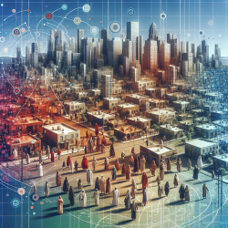
The increasing complexity of urban environments, particularly in multicultural cities like Montreal, necessitates advanced modeling techniques to understand and predict spatial dynamics. A recent study titled A geospatial agent-based model of the spatial urban dynamics of immigrant population: A study of the island of Montreal, Canada explores this complexity through a geospatial agent-based model (ABM). This model simulates the decision-making processes of immigrant populations as they settle in new urban areas.
The Role of Geospatial ABMs in Urban Planning
Geospatial ABMs are powerful tools that simulate interactions between agents (in this case, immigrants) and their environment. By incorporating real geospatial data, these models can predict patterns of spatial composition and segregation. The Montreal study utilized NetLogo software to create a realistic simulation based on various factors such as ethnicity, income, language preferences, and access to amenities.
Key Findings from the Montreal Study
- The model demonstrated realistic spatial patterns of immigrant settlement in Montreal, reflecting the city's diverse ethnographic fabric.
- Immigrants' decisions were influenced by proximity to cultural communities, economic status, access to schools and transportation, and neighborhood quality.
- The study highlighted the importance of public transportation in facilitating access to diverse housing markets for lower-income immigrants.
Implications for Practitioners
Urban planners and policymakers can leverage these findings to enhance integration strategies for immigrant populations. Here are some practical steps practitioners can take:
- Incorporate Cultural Preferences: Recognize the importance of cultural communities in settlement choices. Develop policies that support cultural hubs while promoting integration across diverse neighborhoods.
- Enhance Public Transportation: Improve public transit options to connect immigrants with broader housing opportunities. This can reduce segregation by enabling access to varied neighborhoods.
- Focus on Education and Amenities: Ensure that educational institutions and essential amenities are accessible to immigrant communities. This can influence settlement patterns positively.
- Utilize Advanced Modeling Tools: Adopt geospatial ABMs in urban planning processes to simulate potential outcomes of policy changes and infrastructure developments.
Encouraging Further Research
The Montreal study opens avenues for further research into the spatial dynamics of immigrant populations. Researchers are encouraged to explore similar models in other multicultural cities globally. By doing so, they can uncover unique patterns and develop tailored strategies for urban integration.
The study also suggests expanding the model to include additional factors such as religious diversity and organized discriminatory actions. Such expansions could provide a more comprehensive understanding of urban dynamics.
Conclusion
The integration of geospatial agent-based models into urban planning offers a promising approach to managing the complexities of multicultural cities. By understanding the factors influencing immigrant settlement patterns, practitioners can design more inclusive and sustainable urban environments.
To read the original research paper, please follow this link: A geospatial agent-based model of the spatial urban dynamics of immigrant population: A study of the island of Montreal, Canada.